Sinking cities
Experts predict by century’s end rising oceans will cause significant flooding in coastal cities worldwide. The Sinking Cities Project blends art and science to document the experience of living in such endangered locations — from Indonesia and Bangladesh to Italy and the U.S. Marcin Szczepanski, visual communications director at Michigan Engineering, and Frank Sedlar, BSE ’13/MSE, ’15, hope the images help people better understand the effects of rising sea levels. Images are on display at U-M’s Hatcher Graduate Library through February. (Caption text by Szczepanski.)
-
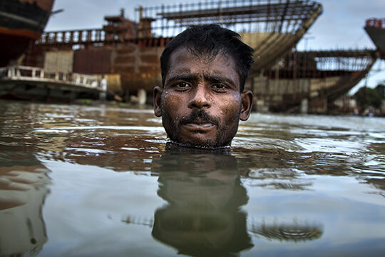
Buriganga River — Dhaka, Bangladesh
Environmental migrant Razek swims in the Buriganga River in Dhaka, Bangladesh. About 400,000 people migrate from farmlands to Dhaka every year. Some 70 percent of them quote environmental shock, such as flooding, as a main reason for migration. These families usually end up in the poorest, most disaster-prone areas of the city where they live in a constant fear of flooding. Most of the country is a low-lying delta through which the Ganges, Brahmaputra, and Meghna rivers discharge into the Bay of Bengal. (Photo: Marcin Szczepanski, 2017.)
-
Southwest Bangladesh
Rice farmer Md. Anarul Islam uses horses to plow his rice paddy before seeding it. He lives in the village of Nurullah, in the Koyra region of Southwest Bangladesh. Rice fields on the coast of Bangladesh are in constant danger of being flooded by brackish water pushed up the rivers by hurricanes from the Bay of Bengal. Saline water poisons the soil and renders it infertile. (Photo: Marcin Szczepanski, 2017.)
-
The coast of Bangladesh
Shrimp farms and rice paddies on the coast of Bangladesh are filled with water during the rainy season. Rice fields in the area are in constant danger of being flooded by brackish water pushed along the rivers by cyclones from the Bay of Bengal. Saline water poisons the soil and renders it infertile. (Photo: Frank Sedlar, 2017
-
Dhaka, Southern Bangladesh
40-year-old Sajeda breaks into tears as she discusses her children’s dismal future in the slums of Dhaka. The family can’t afford the cost of education for the kids. Sajeda and her mother Nurjahan Begum survived seven cyclones in the Chandler District of southern Bangladesh before they lost all their land in river bank erosion. They moved to Dhaka 10 years ago. Since then, they have moved from slum to slum, unable to make enough money to build a permanent shelter. (Photo: Marcin Szczepanski, 2017.)
-
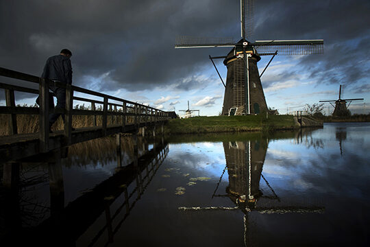
The Netherlands
The Netherlands, located on the floodplains of Europe, is no stranger to regular flooding both by the North Sea and major rivers like the Rhine and Meuse. Some 20 percent of its territory is below sea level and 50 percent less than one meter above it. Over hundreds of years, the Dutch have developed a complicated system of drainage ditches, canals, and windmills that serve as pumping stations. The system kept the low-lying parts relatively dry for habitation and farming. Best preserved windmills are in Kinderdijk, just outside of Rotterdam. (Photo: Marcin Szczepanski, 2017.)
-
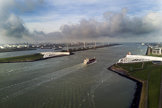
Rotterdam, the Netherlands
Up to 90 percent of the city of Rotterdam is below the sea level, so a flood here would be catastrophic. To stop the surging waters from entering the city, the government built massive floodgates between Rotterdam and the sea. The floodgates are the size of two tubular Eiffel Towers, toppled over. The white arms are usually open, allowing ships to pass. But at the first warnings of storm surge, the robotic arms move out into the canal and cut off the city from the rising sea. (Photo: Marcin Szczepanski, 2017.)
-
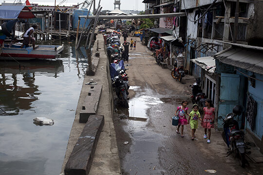
Jakarta, Indonesia
The seawall at the Waduk Pluit neighborhood of Jakarta is a modest two feet wide. The concrete wall is supposed to stop seawater from pouring into urban neighborhoods. According to residents, the water already flows over the wall weekly. It floods the neighborhood that sits two meters below sea level on the other side of the wall. Jakarta is sinking an average of 5-20 centimeters per year. (Photo: Marcin Szczepanski, 2017.)
-
The Java Sea — Jakarta, Indonesia
All that stops the Java Sea from pouring into neighborhoods that lie two meters below sea level is a flimsy wall. To protect the city, Jakarta government has embarked on one of the largest and most expensive civil engineering construction projects in the history of humankind. Critics say the project will displace thousands of local fishermen and that the government is not addressing the causes of the sinking of the city. (Photo: Marcin Szczepanski, 2016.)
-
Ciliwung River — Jakarta, Indonesia
Kids swim in Ciliwung River in a neighborhood called Kampung Bukit Duri in Jakarta. A strip of houses closest to the river here is slated for eviction any day now as part of the “Normalisasi” (normalization) process. This “normalization” turns Jakarta rivers into concrete channels, leveling the houses on both sides of the river, displacing thousands of poor residents and adding concrete walls on the banks. (Photo: Marcin Szczepanski, 2016.)
-
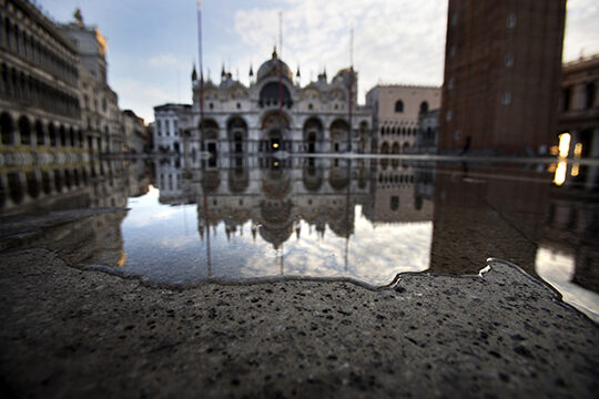
Venice, Italy
Sea water floods St. Marks Plaza in Venice during a high water (acqua alta) phase. Acqua alta is caused by a combination of a very high tide (usually during a full or new moon), low atmospheric pressure, and a wind called scirocco blowing up the narrow, shallow Adriatic Sea. The chronic flooding has severely damaged the city’s foundation. (Photo: Marcin Szczepanski, 2017.)
-
St. Mark’s Plaza — Venice, Italy
A seagull lifts a dead bird floating in the flooded St. Marks Plaza during a high water (acqua alta) period. Currently, parts of the city including St. Mark’s Plaza get flooded more than 60 times per year due to acqua alta. (Photo: Marcin Szczepanski, 2017.)
-
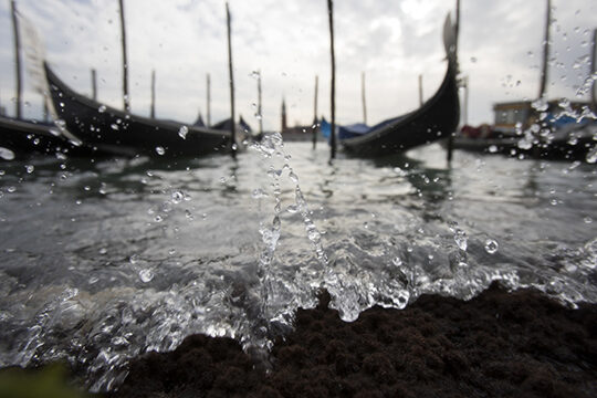
Grand Canal — Venice, Italy
An incoming tide in Grand Canal during acqua alta period sprays and slowly takes over the sidewalk. Venice, a quintessential sinking city, has an intimate relationship with water. The city is situated on 118 small islands that are separated by canals and linked by over 400 bridges. (Photo: Marcin Szczepanski, 2017.)

