No sun up in the sky
Welcome back to my ongoing series that explores plausible, practical climate scenarios relevant to individuals and communities.
In this entry, I write about storms in a way that I think is different. We will see if it works.
Categorically
In a previous Climate Blue column, I proposed that thinking about acute and chronic effects of climate change was a useful way to organize things.
The chronic symptoms were related to the accumulation of heat and whether a region became, over a stretch of time, wetter or drier. This changing of background conditions was often realized by changes in the surfaces around us: rising sea levels, drier forests, saturated ground, less ice on the Great Lakes, and less snow on the ground.
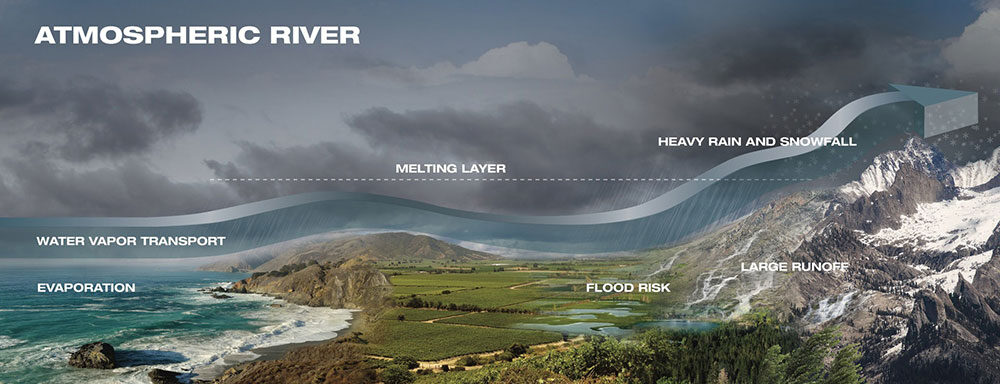
The acute symptoms were related to weather and, especially, extreme weather. When we think of extreme weather, we often think of hurricanes, tornadoes, and hailstorms. We should also put into the pot winter storms. Winter storms are responsible for many of the atmospheric rivers on the U.S. West Coast and increasing coastal flooding on the East Coast.
I introduce one other category, persistent weather. Persistent weather is a way to think about heat waves, which can last several weeks in extreme cases. Another persistent weather effect is when a region gets into a pattern of one storm after another, which is fairly common for winter storms, and it leads to chronic flooding.
For this article, I will focus on storms.
Stormy Monday
We are familiar with thunderstorms, tornadoes, and hurricanes. In recent years, we have become more in touch with derechos, not to mention all sorts of windstorms, such as the Santa Ana winds on the West Coast. Storms are organized in one way or another, and they are temporary. They will come, and they will go.From my perspective, one of the less productive ways climate science carries on in public is talking about whether or not tornadoes and hurricanes are getting more “intense.” This is a tricky question to answer. Usually, by “intense,” we mean wind speed. Wind is gusty and difficult to measure. The most extreme storms are rare; they are often not directly observed. We have a situation in which there is a lot of noise in the observations, and the signal is small. When we find signals of increasing intensity, then they are reported with descriptions of confusing uncertainty.
So, when I see casual references that storms are getting more “intense,” I cringe.
In addition to wind, storms are defined by their temperature and water characteristics. Above, I said that storms are organized in one way or another, and I will describe storms as an organized bundle of characteristics of wind, moisture, and temperature.
If we take a category of storms — hurricanes, for example — we find they are not all the same. Some cover huge areas, some are small with intense high winds, and others contain massive amounts of water. Some move slowly, some move fast. All of these types of hurricanes have existed in the past; they exist today, and they will exist in the future.
On the surface

NOAA’s GOES-16 (GOES-East) satellite caught a dramatic view of the bomb cyclone moving up the East Coast on Jan. 4, 2017. The powerful
nor’easter is battering coastal areas with heavy snow and strong winds, from Florida to Maine.
Notice the long line of clouds stretching over a
thousand miles south of the storm. (Credit: NOAA/CIRAmage courtesy of NASA.)
Now, let’s consider some of the ideas introduced in this series.
The consequences of most storms depend on what is happening at the surface. A slow-moving, low-wind-speed hurricane can cause massive damage because of a storm surge. A hurricane in 2024 with a bundle of characteristics similar to a hurricane of 1964 will cause more flooding because sea levels have risen, and the storm surge will be more significant.
What is happening at the surface depends on how changes have been accumulating. However, the accumulation of changes is not limited solely to the surface. The atmosphere changes as well: It is hotter. Where there is water on the surface, there is more water in the atmosphere. Where there is no water on the surface, the atmosphere is drier.
That is, the background environment in which storms are forming is changing. Since heat and water represent energy available for storms, and since there is more of it, storms have to change. It is implausible to have more energy available and experience no change.
So, how do storms change?
Returning to a conclusion in the first article of this series, there is no one thing climate change will do. Anything in the bundle of wind, temperature, and moisture that forms a type of storm can and will change. Returning to the hurricane example, it could get bigger — with stronger winds, more water, and hence more rain. There might be reasons it would move slower or faster. Hurricanes should be expected to change in any way that is physically possible.
We often think of hurricanes as special types of isolated storms. (They deserve names!) Storms, however, are not isolated individuals. Storms, collectively of all kinds, serve one purpose. They are responding to an uneven distribution of energy and heat. They are the atmosphere’s way of redistributing heat.
If we think of hurricanes in that role of redistributing heat, then if there is more heat, a possibility to move that heat might be a smaller number of large hurricanes or a larger number of small hurricanes. Or the atmosphere could respond by spinning up other types of storms to move around the excess heat.
Storms can change in many ways, and with additional heat, change they must. A focus on changes of one metric in one type of storm is an important detail; however, it is not especially representative of the climate.
Getting heated

(Image courtesy of Ricky Rood.)
I will refer back one more time to an earlier entry in this series. The most fundamental aspect of climate change is the increase in temperature – the accumulation of heat. After that, many dependencies are conditional based primarily on two things. First, is water available at the surface to evaporate into the air? Second, is the temperature above or below freezing?
If there is water available, then one way in which storms will most certainly change is more intense precipitation. If there is sustained availability of water to replenish the atmosphere, then there is likely to be more precipitation. So, when seeking to detect a warming climate’s effects on storms, look to the moisture.
There is one more aspect of storms that I will leave for next time. Storms are not randomly placed around Earth. They do not move willy-nilly.
Next time: Where the storms are.
(The lead graphic shows what happens when atmospheric rivers make landfall. Credit: NASA/JPL-Caltech.)

John Snell - 1970 (sort of...)
One of the examples we used in our “thinking thermally” classes made heat transfer via phase change clear for students: a pound (pint) of water increases 1°F when you add the heat of one kitchen match to it. Cool that same pint and that heat is released to the surroundings. But it takes almost three BOXES of kitchen matches to evaporate that same pint of water—with NO change in temperature. What happens when the vapor condenses is the interesting part because all that energy is released! To a lesser extent (roughly a 1/2 box of matches/pint), the latent heat associate with freezing and melting also moves atmospheric energy. Add more moisture to the atmosphere and more heat and you have a great deal more exciting weather. We’ve created a planet where there are many, many more “boxes” of energy and, as you say, “Since heat and water represent energy available for storms, and since there is more of it, storms have to change. It is implausible to have more energy available and experience no change.”
Reply